Planning Software
Product Information Download
Trimble's Planning Software
Trimble's Planning software is a powerful stand-alone software tool supporting any form of analysis to determine visibility for GPS, GLONASS, IGSO and geostationary satellites. Download Trimble's planning software. It's free!

Some of the features include:
Station location:
Pick your location from a list of cities from all over the world, select your location from the world map or type in your local WGS84 position to do more precise mission planning. Add obstructions to your site to determine the best times for GPS observation.
Pick your location from a list of cities from all over the world, select your location from the world map or type in your local WGS84 position to do more precise mission planning. Add obstructions to your site to determine the best times for GPS observation.
Multi station planning:
Put in multiple station locations to determine the best time to observe these stations simultaneously.
Put in multiple station locations to determine the best time to observe these stations simultaneously.
Sky Plots:
Get detailed sky plots (including obstructions) of your site for any time of the day to aid in determining the best available occupation times.
Get detailed sky plots (including obstructions) of your site for any time of the day to aid in determining the best available occupation times.
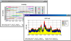
DOP charts:
Chart out the different DOP values by time.
Chart out the different DOP values by time.
Visible satellites:
Get a quick overview on the number of satellites available for your site, for any time of the day.
Get a quick overview on the number of satellites available for your site, for any time of the day.
Many more features...
Download Trimble's planning software. It's free!
[Farm Works Ireland] [Software] [Hardware]
[Demos] [News] [Support]
[Specials] [Find Us] [Calandar]
[Downloads] [Specials] [Find us]
[Contact us] [Links]
[Demos] [News] [Support]
[Specials] [Find Us] [Calandar]
[Downloads] [Specials] [Find us]
[Contact us] [Links]
Surveying Customer Stories